QUARRY
PROJECT
QUARRY
PROJECT
Project overview
The 2,740-hectare Quarry Antimony Project is 46 kilometres northwest of Germansen Landing in the Omineca Mining Division, in BC.
-
In 1991, one sample taken assayed 0.89% g/t Au, 3.8% Cu, 0.34% Zn, 42.5% Pb, and 0.65 g/t Ag and 20% Sb.1
-
Additionally, grab samples retrieved in 1954 yielded assays which averaged 83.5% Pb and 1576 g/t Ag. 1
Source 1: Geological Survey of Canada Memoir – MINFILE No094C 104 EMPR OF *1992-11; 1993-2 Open File 1992-11, Map Number 10 BCGS.
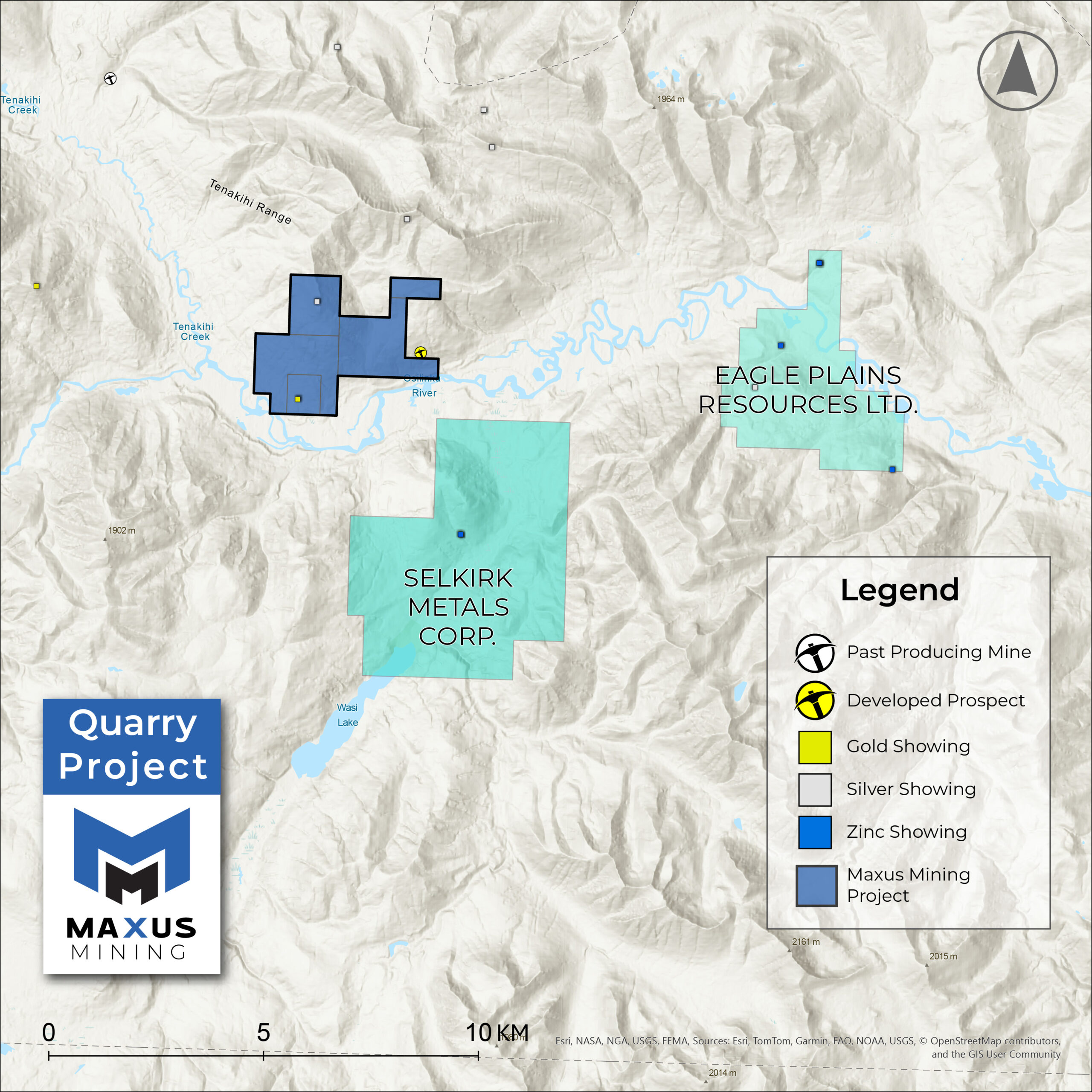
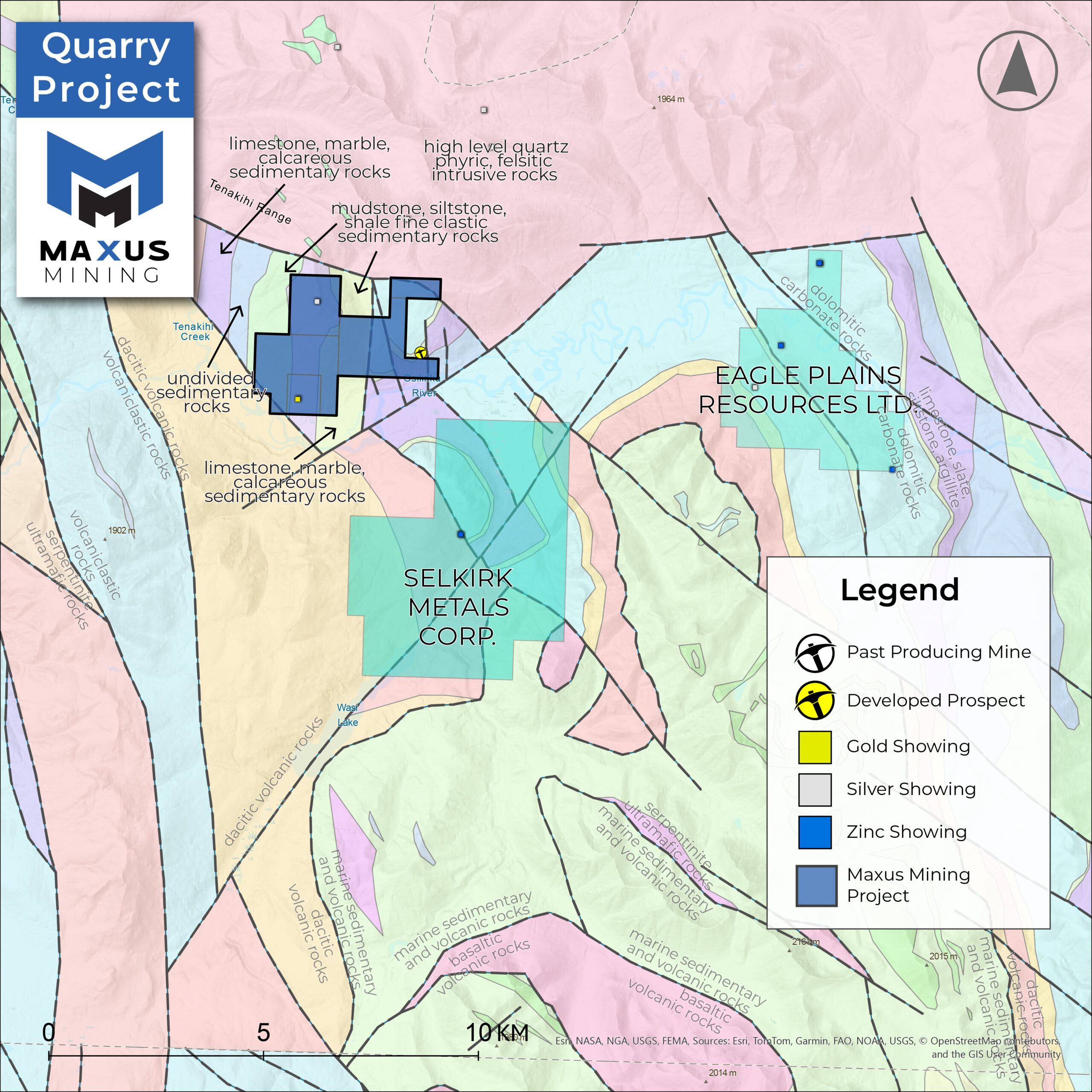
GEOGRAPHY
-
The region is underlain by the Neoproterozoic Ingenika Group and Paleozoic rocks of the Big Creek, Otter Lakes, Atan, Razorback and Echo Lake groups.
-
At the showing, recrystallized and dolomitized limestones of the Neoproterozoic Ingenika Group (Espee Formation) host mineralized quartz veins.
-
Minerals identified include sphalerite, galena, cerussite, chalcopyrite, boulangerite, malachite, azurite and possibly stibnite.
CRITICAL & BASE
METAL POTENTIAL
Including Antimony, Copper, Lead and Zinc.
Polymetallic Mineralization – Historical samples in from the 1990s assayed 0.89% g/t Au, 3.8% Cu, 0.34% Zn, 42.5% Pb, and 0.65 g/t Ag and 20% Sb1
Additionally, grab samples from 1954 yielded assays which averaged 83.5% Pb and 1,576 g/t Ag1
Historical Drilling (1970s) – multiple zones of polymetallic mineralization across over 140 drillholes.
Bullseye Zone at the Beveley Showing – NI 43-101 non-compliant historic estimate of 99,781 tonnes @ 1.42% Pb, 2.24% Zn, and 36.3 ppm Ag (drill-indicated), and 2.72 Mt @ 3.66% Pb + Zn, 36.3 ppm Ag (inferred by block estimate, three zones).2
2025 Prospecting Program – The Company recently completed a ground-truth sampling program across historical showings – assays pending.
Source 1: Geological Survey of Canada Memoir – MINFILE No094C 104 EMPR OF *1992-11; 1993-2 Open File 1992-11, Map Number 10 BCGS
Source 2: Property File PF40196, Suzie Mining Explorations Ltd. Newsletter No. 17, prepared by Keith C. Fahrni, P.Eng., and dated July 14, 1978 – Link

The historical estimate for the Quarry Property is sourced from Property File PF40196, Suzie Mining Explorations Ltd. Newsletter No. 17, prepared by Keith C. Fahrni, P.Eng., and dated July 14, 1978. The estimate is historical in nature and does not include the parameters or categories required under current CIM Definition Standards. There are no directly comparable CIM categories that can be attributed to this estimate, and to the knowledge of the Qualified Person (“QP”), no modern mineral resource or reserve estimates exist for the Property. A qualified person has not done sufficient work to classify the historical estimate as current mineral resources or mineral reserves, and the Company is not treating the historical estimate as current mineral resources or mineral reserves. Work required to upgrade/verify the historical estimate includes a desktop compilation of historical drill data, confirmatory/twin drilling at appropriate spacing, specific-gravity (SG) testing by domain, modern analytical QA/QC with check assays, validation of collar locations and downhole surveys, development of a 3D geological/grade model, and Qualified Person verification to CIM standards.